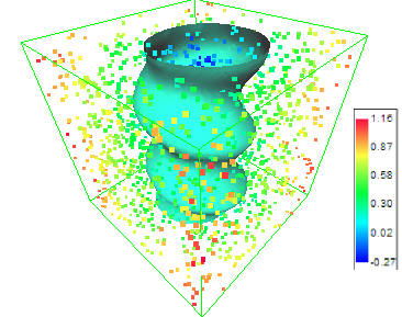
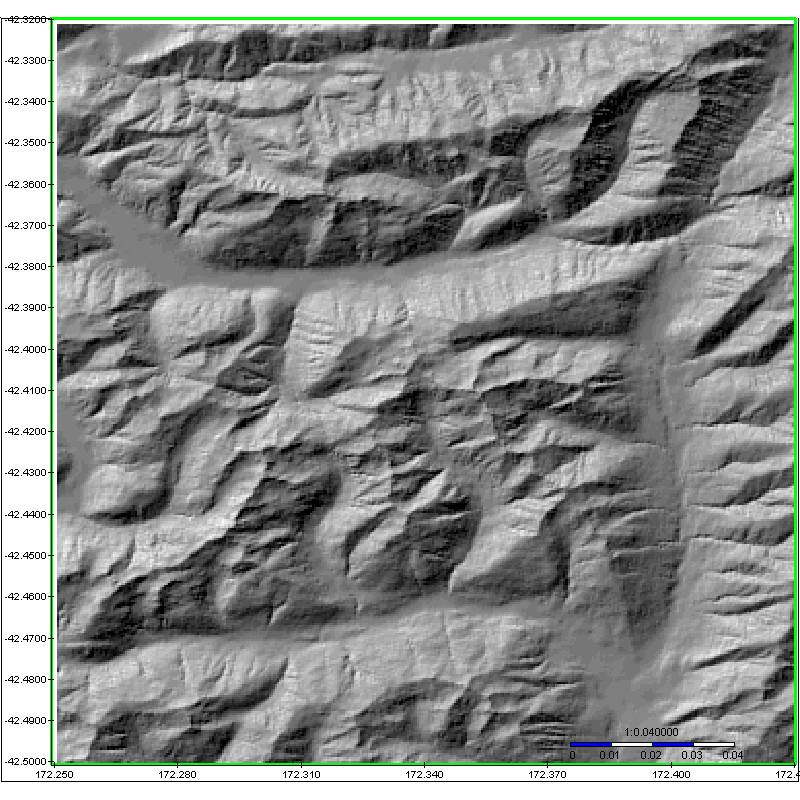


|
|
3DField is a contouring surface plotting and
3D data program that runs under Microsoft Windows
95/98/2000/XP. 3DField converts your data into contour
maps and surface plots. All aspects of 2D or 3D maps can
be customized to produce exactly the presentation you
want.
4D project
3DFieldPro
new version:
-
Volume gridding for 4D scattered
points by 4 gridding methods;
- Create isosurfaces and 3D planes;
- 3D model with irregular grid;
- All options of 3DField.
|
 |
-
Choose the FILE | OPEN command to load:
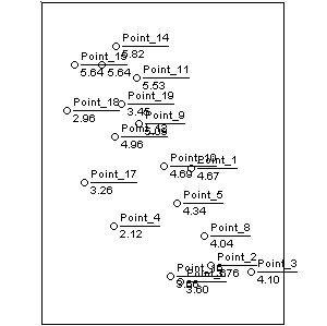
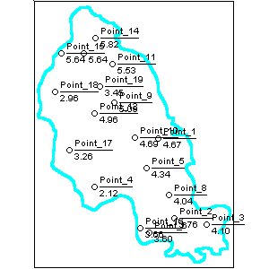
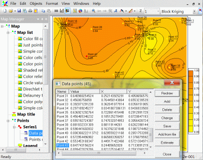
- scattered (X,Y,Z) data points (up to a few
million for registered
version) ;
- scattered (X,Y,Z, links) data points
with links;
- *.SHP files (ArcView ESRI Shapefiles);
- GPS NMEA files (elevations or depths);
- ASCII *.DEM USGS Digital Elevation Model files;
- ASCII *.DXF Autocad files (points and lines entities);
- ASCII *.GEN ArcInfo files (polygons);
- *.CSV files from SonarViewer (Lowrance
Electronics, Inc);
- *.SLG Lowrance Sonar Log Data files
using SLG2TXT utility from Lowrance
Customer Service;
- *.GRD Surfer 6, Surfer7 and Surfer8 files;
- *.ASC ArcInfo compatible ASCII grid
format;
-
1" and 3" SRTM data in HGT
format (with .HGT extension)
- *.DBF DBase files;
- BMP, JPG, PNG, GIF, TIFF, GeoTIFF pictures;
- *.3DF 3DField documents;
- *.PNG files with the 3DField data
inside logo.
|
|
- Choose the FILE | OPEN 2D/3D DATA command to load 2D/3D matrix data {Zijk}
- Choose the FILE | IMPORT GPS DATA command to load
data (waypoints, tracks, routes and
links) from GPS files:
Cetus for Palm/OS; CoPilot Flight Planner for
Palm/OS; DeLorme GPL; DeLorme (drawing) file; DeLorme Street Atlas Route; EasyGPS binary format; Garmin Mapsource: Garmin PCX5; GeocachingDB for Palm/OS; GeoGrid-Viewer; GeoNiche .pdb; GpilotS; GPSPilot Tracker for Palm/OS; Holux
(gm-100) Format; KuDaTa PsiTrex text; Lowrance USR; |
Magellan Mapsend; Magellan NAV Companion for
Palm/OS;
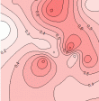
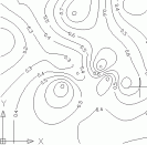
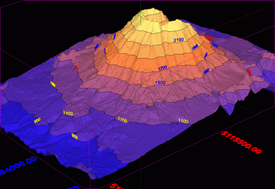
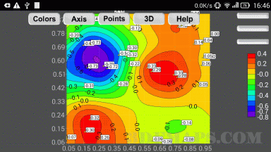
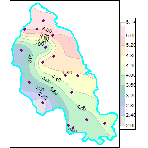
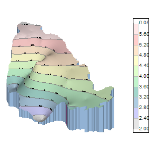
 Magellan serial protocol; Magellan SD files (as for
Meridian); Magellan SD files (as for
eXplorist); Motorrad Routenplaner (Map &
Guide); MS PocketStreets 2002 Pushpin; National Geographic Topo; NMEA 0183 sentences; Quovadis; OziExplorer; PathAway Database for Palm/OS; TomTom POI file; TopoMapPro Places File; Vito Navigator II tracks; U.S. Census Bureau Tiger Mapping
Service; |
 |
- Result maps:
- black and white contour map; - 
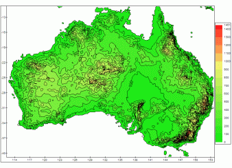
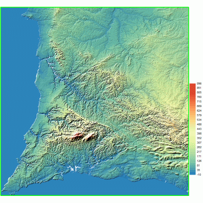
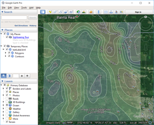
color fill contour map; - color cells map; - color points map; - Direchlet color tesselations map; - Delauney triangles map; -
color and
monotone relief map; - circle values map; - color polygons map; - pie map; - various data visualization charts; -
3D view relief contour maps; -
graph maps; - OpenGL 3D map with contours and
textures.
|
 |
- Export:
- 3D mesh (surface) in Autocad DXF
format; - contours with labels in Autocad
DXF format; - contours as 3D polylines in Autocad
DXF format; - contours as 3D polylines in ArcView ESRI Shapefiles
SHP format; - data points in Autocad DXF format; - points, contours and drawing lines as
waypoints, routes and tracks to
GPS files; - *.GRD Surfer 6 files; - 2D mesh of triangles in text format; - 2D/3D mesh of triangles in Autocad DXF
format. |
3DField |
Export to
Autocad |
Autocad |
- Save as:
- *.3DF (3DField digital data
document); - *.PNG (digital data and picture of
your data in same file).
- 7 gridding methods (Radial
Basis Functions, Inverse
Distances, Triangulation, Kriging,
Minimum Curvature, Natural Neighbors,
Linear System )
- Automatic or user-defined contour intervals and ranges
- Control over contour label format, font, frequency and spacing
- Automatic or user-defined color for contour lines
- Color and texture fill between contours, either user-specified or as an automatic spectrum
of your choice
-
Base map attached to data points
- Data analysis, histogram for scatered
points and interpolated grid values
- Regression 2D data
- Splines for lines and contours
-
View and zoom BMP, GIF, PNG, JPG,
TIFF and GeoTIFF images
- Automatically and manually digitize image
- Import and export lines
- Ascending or descending sort for
values or coordinates of points
-
OpenGL view with full screen rotation.
- Textures
-
Convert a contour bitmap to a 3D view
- Output maps as EMF, WMF, BMP, JPG, PNG,
GeoTIFF file formats
- Insert maps (EMF or bitmap) in any document Microsoft Office
- Multipage scale print
- Multilingual interface
Frequently-Asked Question with Answers
Also you can purchase the
gridding and contouring
libraries |
Download
3DField v 2.9.7 (2.8 MB)
new

|
If you have data: |
| X |
Y |
Value or Z
(option) |
Name
(option) |
| 26070 |
46750 |
4.6750 |
Point_1 |
| 27890 |
37640 |
3.7640 |
|
| ... |
... |
... |
|
| 24080 |
36560 |
3.6560 |
"Point 23" |
|
|
Load the data set by Open command |

|
|
Draw the boundary or load it ( if it
is necessary) |

|
|
You can format the
contour map and import it as EMF, WMF, BMP,
PNG, JPG, GIF file (it is possible through Clipboard) in any document Microsoft Office.
|
 |
|
Click the OpenGL View button
|
 |
For 4D scattered points
3DFieldPro
new version
|
 |

Download
3DField v 2.9.7 (2.8 MB)
new
You can register your copy of 3DField at a cost of $99
or Euro 79.
|
This program can be registered through ShareIt

in Euro.
|
This program can be registered through RegSoft.com

in $.
These above forms will also give users options to purchase via Voice,
Fax, or Postal Mail.
|
Upgrade free
Vladimir Galouchko author 3DField
If you have comments or suggestions, feel free to
send me a message at

|